Have you ever had to risk lowering the flight altitude when operating a UAV at a height of 100 meters because you could not see subtle defects in the distance clearly during the day? Have you ever been forced to halt critical operations because your vision completely failed after nightfall? Have you ever caused data deviations and decision-making errors due to the inability to accurately measure the distance to a target?
These are not isolated incidents, but common pain points faced by almost all UAV industry practitioners. The limitations of a single sensor are becoming the biggest bottleneck restricting the expansion of UAV applications into deeper and broader fields.
Today, we want to delve into a product that truly addresses these pain points — the four-sensor gimbal, integrated with a 40x ultra-clear optical zoom visible light camera, 640×512 high-resolution thermal imaging, and a high-precision laser rangefinder. It is not a simple stack of sensors, but a “one-stop perception solution” we have polished over two years based on the actual needs of thousands of industry scenarios.
I. Why Do We Need “Four-in-One Sensing”? The Era of Single Sensors Is Coming to an End
In the early stages of UAV industry development, a single visible light camera was sufficient to meet basic aerial photography needs. However, as application scenarios extend from simple landscape shooting to professional fields such as power inspection, security monitoring, emergency rescue, and forest fire prevention, the shortcomings of single sensors have become evident:
Visible light cameras: Rely on light conditions and completely fail in nighttime, foggy, or smoky environments; details are blurred during long-distance shooting, making it impossible to identify tiny defects.
Pure thermal imaging cameras: Only display heat source distribution, unable to see the texture and details of objects; it is difficult to accurately determine the specific identity and characteristics of targets.
Gimbals without ranging function: Only provide visual information, unable to obtain precise position, size, and distance data of targets; cannot support accurate surveying and mapping, target tracking, and strike guidance.
We have seen too many such cases: power inspection personnel found that the cracks on insulators were blurred in photos taken with ordinary cameras after returning to the ground, and had to fly again; security personnel could only see a blurry heat source during nighttime monitoring, unable to judge whether it was an animal or an intruder; rescue personnel found the figure of a trapped person during mountain search and rescue, but could not accurately state their location, leading to a significant delay in rescue time.
It is these real pain points that have strengthened our determination to develop the four-sensor gimbal. We believe that the future UAV perception system must be an integrated body of multi-sensor fusion, all-weather operation, and high-precision positioning.
II. Core Technology Analysis: Every Sensor Reaches the Industry’s Top Level
The power of the four-sensor gimbal stems from the careful selection and optimization of each core sensor, as well as the realization of in-depth software and hardware integration.
2.1 40x Ultra-Clear Optical Zoom: Not Just “Seeing Far”, But “Seeing Clearly”
Many people’s understanding of zoom is limited to “the higher the magnification, the better”, but in fact, the image quality of optical zoom is the key. Digital zoom simply enlarges pixels, leading to severe image blurring; while true optical zoom achieves magnification by changing the focal length of the lens, which can maintain image clarity.
Our four-sensor gimbal adopts a 40x continuous optical zoom lens, combined with a 1/2.8-inch CMOS sensor, which can clearly identify license plate numbers on the ground at a flight height of 100 meters; see subtle cracks on power insulators at a distance of 200 meters; and recognize facial features within a range of 500 meters.
More importantly, we have added intelligent anti-shake and autofocus technology, which can obtain stable and clear images even in windy weather and high-speed flight conditions. This is crucial for security and inspection tasks that require long-term target tracking.
2.2 640×512 High-Resolution Thermal Imaging: “Eagle Eyes” That Penetrate Darkness and Obstructions
The core advantage of thermal imaging technology is that it can detect infrared radiation emitted by objects, unaffected by light conditions. Whether in pitch-black nights, foggy weather, or smoky fire scenes, thermal imaging cameras can clearly display the outline and temperature distribution of objects.
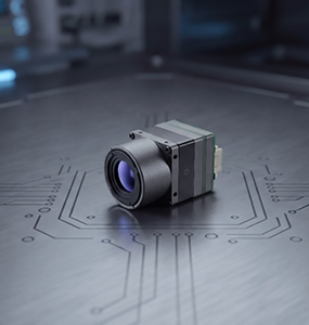
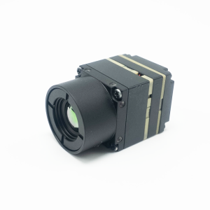
We have selected a 640×512 resolution uncooled infrared detector, which is a mainstream high-end configuration in current industrial applications. Compared with the common 320×240 resolution thermal imaging, its pixel count is increased by 4 times, enabling it to detect smaller heat sources and identify farther targets.
In practical applications, 640-resolution thermal imaging can detect human targets at a distance of 1000 meters at night; in power inspection, it can accurately detect tiny heating points of equipment and early warn of faults; in forest fire prevention, it can detect smoke points at the initial stage of a fire, winning valuable time for fire fighting.
2.3 High-Precision Laser Rangefinder: Making Every Positioning Accurate
If visible light and thermal imaging solve the problem of “seeing”, then the laser rangefinder solves the problem of “positioning”.
Our four-sensor gimbal integrates a high-precision laser rangefinder with a ranging range of up to 2000 meters, with a measurement accuracy of ±0.5 meters. It can quickly measure the straight-line distance from the UAV to the target, and calculate the precise geographic coordinates of the target in combination with the UAV’s GPS and attitude data.
This function is indispensable in many scenarios: in surveying and mapping operations, it can quickly obtain 3D terrain data; in emergency rescue, it can accurately inform rescuers of the location of trapped people; in security monitoring, it can accurately calculate the distance and moving speed of intruders.
III. From Laboratory to Field: The Value of the Four-Sensor Gimbal in Real Scenarios
The value of technology is ultimately reflected in practical applications. Over the past year, our four-sensor gimbal has been widely used in multiple industries such as power, security, emergency response, and forestry, helping users solve many practical problems.
In the field of power inspection: A power grid company used our four-sensor gimbal for transmission line inspection. During the day, the 40x optical zoom was used to check the appearance defects of insulators, conductors, and hardware fittings; at night, thermal imaging was used to detect the heating of equipment; and the laser rangefinder was used to measure the sag of conductors and cross-span distances. One flight can complete tasks that previously required multiple flights, improving inspection efficiency by more than 3 times and increasing fault detection rate by 40%.
In the field of security monitoring: A large industrial park installed a UAV inspection system equipped with our four-sensor gimbal, achieving 7×24-hour uninterrupted patrol. During the day, the 40x zoom camera can clearly monitor every corner of the park; at night, the thermal imaging camera can automatically detect intruders and issue alarms; the laser rangefinder can accurately locate the position of intruders and guide security personnel to handle them quickly.
In the field of emergency rescue: A fire and rescue detachment successfully found two hikers trapped in a valley at night using a UAV equipped with a four-sensor gimbal during a mountain search and rescue mission. The thermal imaging camera penetrated the dense forest and clearly showed their positions; the laser rangefinder accurately measured their altitude and distance, enabling rescuers to plan the optimal route and ultimately rescue them successfully in the shortest time.
IV. Our Persistence: Building UAV Perception Products That Truly Understand the Industry
In this era of serious product homogenization, many manufacturers are competing on parameters and prices, but we have always believed that a truly good product should understand users and the industry.
More than half of our R&D team has experience in frontline industry applications. We have personally climbed transmission towers, kept night shifts in industrial parks, and participated in emergency rescue missions. We deeply understand the problems users encounter in actual work, know what functions are truly useful, and what parameters are flashy but impractical.
Therefore, at the beginning of the design of our four-sensor gimbal, we fully considered the actual needs of industry users:
Industrial-grade quality: Adopts an all-metal body with IP54 protection rating, capable of normal operation in a temperature range of -20℃ to +55℃, adapting to various harsh environments.
High compatibility: Supports mainstream UAV platforms, plug-and-play, no complicated modification required.
Open SDK: Provides a complete Software Development Kit (SDK), allowing users to carry out secondary development according to their own needs and integrate it into their own systems.
Comprehensive after-sales service: We provide 7×24-hour technical support, as well as on-site training and maintenance services nationwide, to ensure that users’ equipment is always in the best condition.
V. Working with the Industry to Explore the Infinite Possibilities of UAVs
The development of UAV technology is profoundly changing the working methods of various industries. As the “eyes” of UAVs, the perception system is a key factor determining its capability boundaries.
Our original intention in developing the four-sensor gimbal is not to create a “parameter monster”, but to provide a truly easy-to-use, durable, and effective tool for every industry practitioner pursuing excellence in complex scenarios. We hope that through our efforts, UAVs can play a role in more fields, helping users improve efficiency, reduce costs, and ensure safety.
In the future, we will continue to deepen UAV perception technology and launch more products that meet industry needs. We also look forward to cooperating with more industry partners to jointly explore the infinite possibilities of UAVs.
If you are also troubled by the limitations of UAV perception systems, or if you want to learn how the four-sensor gimbal can create value for your business, welcome to visit our official website or contact our technical team. We are happy to communicate with you and share our experience and insights.