Drone Four-Sensor Gimbal Payload Forest Fire Prevention Case Study: Intelligent Prevention and Control Solution for Forested Areas in California, USA
1. Project Background
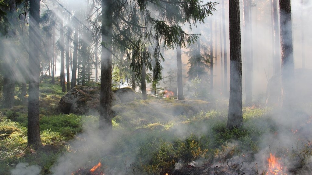
The U.S. state of California has more than 33 million acres of forest and wilderness, making it one of the highest-risk regions for forest fires in the United States. With its dry climate and complex terrain, during the wildfire season from June to November each year, scattered ignition sources can spread rapidly under strong winds and develop into catastrophic fires, posing serious threats to ecosystems and to residents’ lives and property.
Traditional forest fire prevention mainly relies on ground patrol personnel, manual observation from watchtowers, and manned helicopter patrols. These methods have pain points such as limited coverage, slow response, poor nighttime operating capability, and high personnel safety risks. Especially in remote mountain areas and complex canyon terrain, traditional methods struggle to deliver all-weather, full-coverage fire monitoring.
To improve the intelligence level and emergency response capability of forest fire prevention, California forestry and fire departments introduced a multirotor drone fleet equipped with the LUX-H40 series four-sensor gimbal payload, building an integrated “air-ground” intelligent forest fire prevention system.
2. Core Challenges
Low patrol efficiency over large forest areas: California’s forest areas are vast, and traditional ground patrol personnel can cover only dozens of square kilometers per day on average, making normalized full-region monitoring difficult.
Difficult early fire detection: smoldering fires under the forest canopy and small nighttime ignition sources are highly concealed, making them difficult to identify with the naked eye or ordinary visible-light cameras.
Delayed fire situation assessment: after a fire occurs, traditional methods cannot quickly obtain precise ignition point locations, fire spread ranges, or temperature distributions.
High personnel operating risk: wildfire scenes involve high temperatures, heavy smoke, and complex terrain, creating major safety threats for ground crews and manned helicopter operations.
Insufficient nighttime and severe-weather operating capability: traditional optical equipment is almost ineffective at night and in heavy fog or dense smoke.
3. Solution
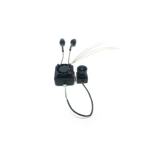
Based on the actual needs of forest fire prevention in California, 20 industrial-grade drones equipped with the LUX-H40 four-sensor gimbal payload were deployed to build an intelligent drone patrol and prevention system covering key forest areas across the state. The LUX-H40 four-sensor gimbal payload integrates a 40x ultra-HD optical zoom camera, a 12-megapixel wide-angle camera, a 640×512 uncooled infrared thermal imaging camera, and a 1,500-meter high-precision laser rangefinder. Combined with a three-axis stabilized gimbal and AI algorithms, it enables full-process automation across “discovery – identification – location – tracking – assessment.”
Core Application Scenarios and Technical Implementation
1. All-Weather, Full-Region Fire Monitoring
Routine patrols: drones fly automatically along preset routes. The 12-megapixel wide-angle camera on the LUX-H40 payload provides an 82-degree large field of view. A single sortie can cover more than 50 square kilometers, delivering over 10 times the patrol efficiency of ground patrols.
Nighttime and dense-smoke penetration: the 640×512 infrared thermal imaging camera can penetrate dense smoke, heavy fog, and darkness, detect temperature differences of 0.1 deg C, and identify a cigarette-butt-sized smoldering ignition source from 3 kilometers away.
Intelligent early warning: the built-in AI algorithm automatically identifies abnormal high-temperature points in infrared thermal images and pushes alarm information to the command center in real time, with a false alarm rate below 5%.
2. Precise Fire Location and Situation Assessment
Accurate ranging and positioning: the 1,500-meter laser rangefinder can quickly measure the line-of-sight distance between the fire point and the drone. Combined with the drone’s GPS coordinates, it enables centimeter-level longitude and latitude positioning of the fire point.
Fire spread mapping: through the global temperature measurement function of infrared thermal imaging, the system generates a temperature heat map of the fireground, intuitively showing fire distribution and spread direction.
Multidimensional data collection: the 40x optical zoom camera can clearly observe fireground details from 1 kilometer away, identify fuel types, flame height, and smoke concentration, and provide a basis for firefighting plan development.
3. Real-Time Command and Dispatch During Firefighting
Real-time video backhaul: through a 100 Mbps Ethernet interface, dual visible-light and infrared video streams are transmitted back to the command center in real time. Picture-in-picture and split-screen display modes are supported, enabling simultaneous monitoring of the overall fireground and key areas.
Automatic fire-front tracking: AI algorithms can automatically lock onto and continuously track the movement of the fire front. The gimbal’s 0.01-degree stabilization accuracy ensures the image remains clear and stable.
Rescue force guidance: laser ranging and coordinate annotation functions guide ground firefighting teams and helicopters for precise delivery of firefighting materials.
4. Post-Disaster Assessment and Hidden-Risk Inspection
Burned-area statistics: infrared thermal imaging data is used to quickly calculate burned area and damage severity.
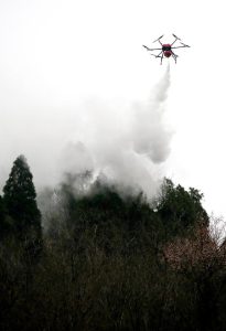
Residual fire inspection: after the fire is extinguished, a drone equipped with the LUX-H40 payload performs a comprehensive scan of the fireground to discover and locate underground smoldering fire points and prevent reignition.
4. Application Results
Since the LUX-H40 four-sensor gimbal payload drone system was put into use, California’s forest fire prevention capability has improved significantly:
Fire detection time was shortened from an average of 4 hours to 15 minutes, and the early-stage fire response rate increased by 85%.
The patrol coverage area per sortie increased by 10 times, while patrol costs decreased by 60%.
During the 2025 wildfire season, the system successfully issued early warnings and supported the handling of 37 early-stage fires, preventing multiple major forest fires.
High-risk personnel operations were reduced by more than 90%, significantly lowering casualty risks for firefighters.
Firefighting efficiency increased by 50%, and the average burned area decreased by 40%.
5. Customer Feedback
“The LUX-H40 four-sensor gimbal payload has completely changed the way we conduct forest fire prevention. Its infrared thermal imaging capability enables us to detect early-stage fires at night and in dense smoke, while the 40x optical zoom and laser ranging functions provide precise situational awareness data. This system has not only improved our work efficiency, but more importantly, it has protected the lives of our firefighters.” – Drone Project Lead, California Forestry and Fire Department
6. Conclusion
With its multi-sensor fusion, high integration, lightweight design, and intelligence, the LUX-H40 series four-sensor gimbal payload is ideally suited to complex forest fire prevention scenarios. It not only addresses the pain points of traditional forest fire prevention methods, but also provides forestry departments with a new intelligent operating model, enabling a shift from “passive firefighting” to “active prevention.” In the future, as AI algorithms continue to iterate and drone technology develops further, the LUX-H40 four-sensor gimbal payload will play an increasingly important role in forest fire prevention, ecological protection, and other fields.
Selected Cases
Featured Products